

Trusted in the Field for Over 50 Years
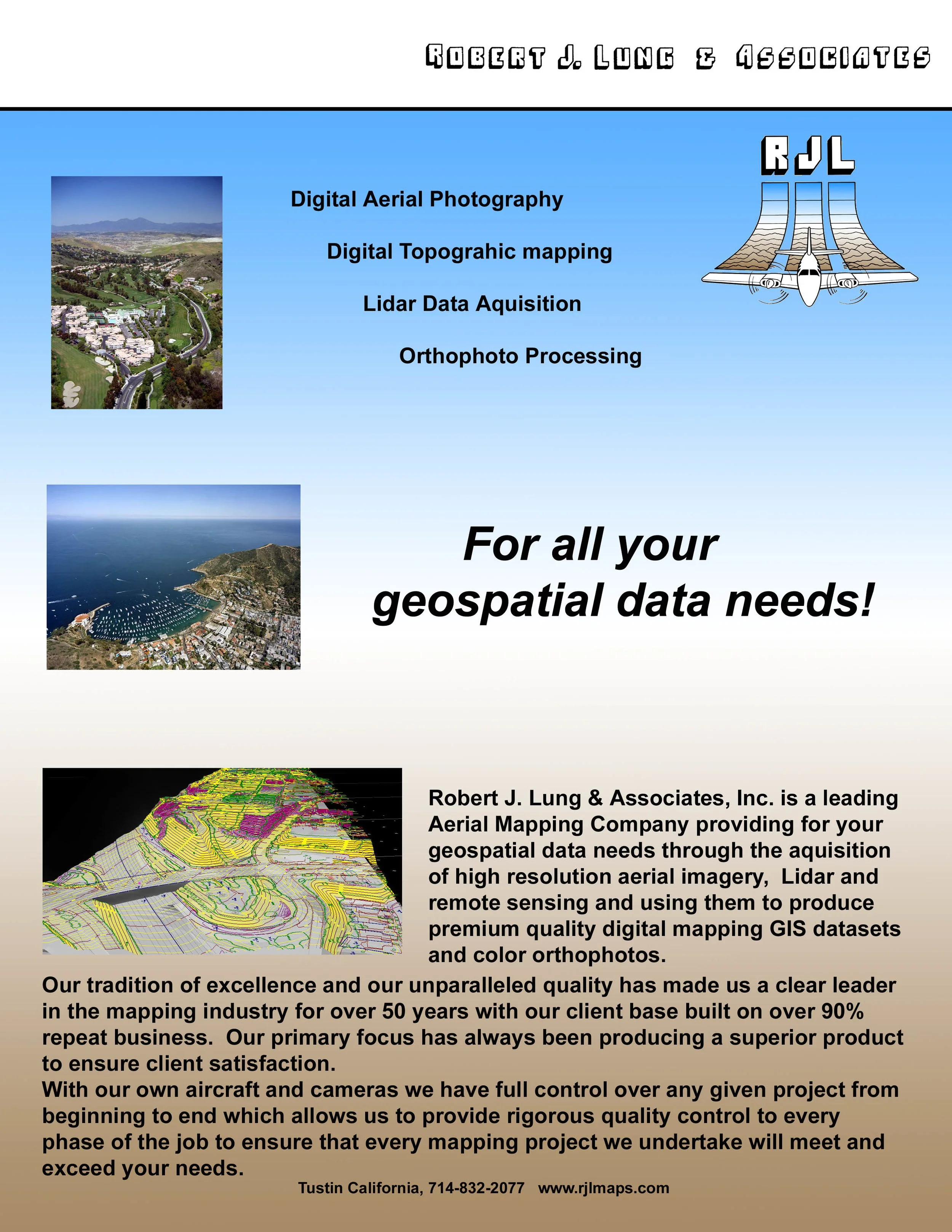
For over 50 years, Robert J. Lung & Associates, Inc. has been a trusted name in aerial mapping, built on a foundation of precision, reliability, and an unwavering commitment to client satisfaction. Operating out of Tustin, California with aircraft based in Chino, California, we provide end-to-end geospatial data solutions from aerial photography to topographic mapping, orthophoto processing, and LiDAR acquisition; all for clients across a wide range of industries and project types. What sets us apart is our ability to own and control the entire process: with our own aircraft, cameras, and in-house processing capabilities, we deliver rigorous quality control at every stage of a project. The result is a track record that speaks for itself, with over 95% repeat business from clients who know that when they come to RJL, the data will be right. RJL is WBE, WOSB and California Small Business Certified.
Open Weekdays from 8:00am - 5:00pm


Our Team
Laure Reed
Laure Reed leads RJL & Associates as Chief Executive Officer, bringing over two decades of leadership in geospatial technologies and business operations. Under her guidance, the firm has reinforced its commitment to precision mapping, LiDAR, and photogrammetric services while expanding client-focused solutions across infrastructure, environmental, and resource management sectors. Her strategic vision emphasizes operational excellence, data integrity, and the practical application of emerging remote-sensing technologies.
Laure combines technical fluency with commercial acumen. She prioritizes investment in staff development and advanced workflow automation to ensure timely, high-quality deliverables. She is pragmatic and detail-oriented; clients appreciate her responsiveness and clear communication on complex projects.
Reed champions partnerships that enhance RJL’s service portfolio and geographic reach, fostering collaborations with public agencies, private developers, and academic institutions. She also supports the company’s sustainability and safety initiatives, integrating responsible field practices and data governance standards into everyday operations. Under her leadership, RJL continues to build on a 50-year legacy of trusted aerial mapping and geospatial innovation.
Chief Executive Officer
Chris Lung serves as the current President of Robert J. Lung & Associates, bringing decades of practical experience and steady leadership to the firm. He began his career at the company in the summer of 1984, learning the technical foundations of imaging while working in the color and black and white labs. That early hands-on exposure to photographic processes instilled a deep appreciation for quality and precision that has defined his approach throughout his career.
In 1991, Chris earned his Commercial Pilot rating, coinciding with the company's acquisition of its first aircraft, a milestone that significantly expanded RJL's capabilities in aerial data collection and marked a new chapter in the firm's growth. Taking to the controls, Chris developed a firsthand understanding of flight operations, mission planning, and the technical demands of airborne data collection that few in the industry can match. He became a Principal in 2010 and now leads client-facing efforts in sales, job planning, and project costing, ensuring every project is structured to meet both technical specifications and budget expectations from the outset.
As an experienced pilot and specialist in aerial photogrammetry, Chris brings a rare combination of operational depth and client-centered perspective to every engagement. He understands the full arc of a project from initial scoping and flight planning through to final data delivery, and uses that knowledge to anticipate challenges, manage risk, and keep projects on track. His commitment to accuracy, safety, and clear communication has been instrumental in building the long-term client relationships that RJL has become known for, and his leadership continues to drive the firm's reputation for reliable, high-quality mapping, LiDAR, and photogrammetric services.
PrincipalChris Lung
Robert J. Lung
Robert J. Lung founded Robert J. Lung & Associates in 1976 on principles forged during his service with the U.S. Army's 8th Intelligence Division. In the military he learned that reliable information, rigorous methodology, and disciplined execution save time and lives. Those lessons became the foundation of a company built to deliver precise, actionable geospatial data.
When he left active service, Robert saw an opportunity to apply intelligence techniques such as meticulous data collection, rigorous verification, and structured analysis to civilian mapping and surveying. At a time when aerial mapping relied on film cameras and manual drafting, RJL pushed to improve accuracy and repeatability, investing in better instrumentation, documenting processes, and training teams to think like analysts. Always asking how data would be used, what uncertainties existed, and how to reduce them.
The company's longevity rests on three core commitments. Precision: using the best methods and instruments available and verifying results through repeatable quality checks. Integrity: presenting data and deliverables transparently, documenting limitations and confidence levels. Service: responding to client needs with professionalism and a focus on solving real-world problems. These principles, established by Robert on day one, continue to define what Robert J. Lung & Associates stands for today.
Founder
Mike McCarthy
Mike serves as Operations and Project Manager at Robert J. Lung & Associates, bringing a strong technical foundation in GIS and CAD platforms to a role that spans the full arc of project execution and firm operations. His background in geospatial software and data workflows gives him a sharp eye for what good data looks like and the technical fluency to communicate effectively with both the production and data collection teams under his oversight.
Day to day, Mike works closely with RJL's production and data collection staff to coordinate workflows, manage scheduling, and keep projects moving on track and on deadline. His ability to understand the technical demands of each phase of a project, from data capture through processing and final compilation, makes him an effective bridge between the teams doing the work and the clients waiting on the results.
Before any deliverable leaves the firm, Mike conducts a thorough final review and edit of the data himself, ensuring that every product meets RJL's quality standards and the specific requirements of the client. He then personally delivers the finished datasets, a detail that speaks to the level of accountability and client care that defines his approach. That direct involvement from project coordination through final delivery gives clients confidence that their data has been reviewed with care and that the person handing it off knows it inside and out.
Data Operations & Project Manager
As a Photogrammetrist at Robert J. Lung & Associates, Blake plays a critical role in both the airborne and office phases of the firm's mapping workflow. In the aircraft, Blake operates the aerial camera and flight management system, monitoring sensor performance, managing flight line execution, and ensuring that imagery is captured with the correct overlap, resolution, and exposure needed to meet project specifications.
On the ground, he manages the transfer and ingestion of raw imagery into the firm's processing pipeline, overseeing quality checks at each stage to ensure data quality from the moment the aircraft lands. This hands-on involvement in the transition from field collection to office processing gives Blake a thorough understanding of the full data lifecycle and an ability to identify and resolve issues early before they affect final deliverables.
From there, he moves into photogrammetric data collection, extracting planimetric features, elevation data, and mapping products directly from the imagery using softcopy workstations and geospatial software. This end-to-end involvement, from operating the camera at altitude to delivering finished mapping datasets, reflects the kind of versatile technical expertise that defines the RJL team and ensures consistency and quality across every phase of a project.
Photogrammetric AnalystBlake Lung
Our Production Team
The rest of the production team at Robert J. Lung & Associates forms the technical backbone of the firm's mapping and data collection capabilities, working with stereo 3D imagery and industry-leading softcopy photogrammetric software to extract precise geospatial data directly from aerial photography. Using stereoscopic viewing technology, each team member interprets overlapping image pairs as a three-dimensional model of the terrain, allowing them to collect elevation data, planimetric features, and topographic information with a level of accuracy and detail that ground-based methods alone cannot match.
Working from calibrated aerial imagery captured by RJL's own aircraft and camera systems, the production team compiles a wide range of mapping deliverables including digital terrain models, contour lines, breaklines, planimetric feature datasets, and orthomosaic products. Their familiarity with the full photogrammetric workflow, from image orientation and model setup through final feature collection and QC, ensures that the data they produce is geometrically sound, internally consistent, and ready for use in GIS, CAD, and engineering platforms.
The depth of experience across the production team is one of RJL's most significant assets. Many team members have spent years, and in some cases decades, developing the precision and spatial judgment that stereo photogrammetric work demands. That accumulated expertise, combined with a rigorous attention to detail and a thorough understanding of client needs, is what allows RJL to consistently deliver mapping products of the highest quality on projects ranging from small site surveys to large-scale corridor and regional mapping programs.
Data Compilers